Picture the scene. It's February, everywhere is still in lockdown, and pretty much everything that pops up on the news is still awful so you basically hate everything.
But it's the weekend and the sun is shining. I felt a huge urge to stand on top of a hill with the wind in my hair. Unfortunately 'stay local' when you live just near Gloucester doesn't leave much scope for that...
Sandhurst Hill stands a mighty 88m above sea level. But it is right next to the river and is actually fairly prominent, so you can easily pretend. A 7km route takes you... continue reading »
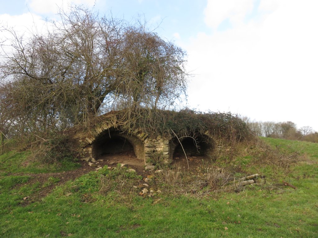
Another walk, this time from Ben Giles' Wye Valley book.
The book suggests starting at the pub, but after a little googling I discovered that there's much more parking space at Woolhope parish hall just up the road.
Leaving the village, we walked up a lane that turned into a track, and then just a footpath in a field - which also contained some old lime kilns. After a slight descent, it was back up the hill through more fields until we reached the road along the ridge at Hooper's Oak.
The views from the ridge weren't bad for a slightly damp December... continue reading »
I've recently started a new job! I'll still be working remotely, but spent the first few weeks doing induction stuff and getting to know my colleagues in the actual proper office. In Kent. This is very definitely not a commutable distance from Gloucester (I hate you M25/M26/M20...), so I was put up in an Airbnb for the duration.
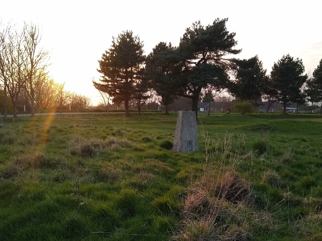
The clocks had just gone forward - hurrah! - so what better way to fill my spare time than scouring OS maps for little blue triangles and/or other things to investigate. Certainly better than spending all evening watching TV and eating chocolate (might... continue reading »
Ordnance Survey declared Sunday 30th September to be National Get Outside Day, which seems like an excellent idea to me.
I joined Zoe and Sarah for a '#GetOutside activity challenge' weekend - fitting as many outdoor activities in as possible. I was only available for the one day, but still managed to tick off quite a few thing.
Tilly and I met them at Robinswood Hill in Gloucester - very important to get 'dog walking' on the list! Here we are being unphotogenic at the toposcope - which is a bit shorter than the nearby trigpoint, and so easier to lift a... continue reading »
Last week I attended the Outdoor Bloggers weekend in Snowdonia. It's been a while since I met (in real life) any random people from the internet, and I've never really done any sort of networking so wasn't quite sure what to expect.
Despite an afternoon off work and good intentions, I arrived in the dark. Good thing my tent only takes a few seconds to put up! We were camping at Llyn Gwynant, which rather conveniently features a pizza shop on busier weekends. Yum yum!
We sat around the campfire telling stories and getting to know each other a bit - though... continue reading »
This year marks the 80th birthday of the trig pillar. To celebrate, Ordnance Survey have been running a Twitter/Instagram photo competition.
A few weeks ago one of my pictures (this one) was chosen as a winner. Exciting!
So here I am, standing next to one my local trig points modelling my shiny new tshirt. I feel I should also point out that the messy flowers are nothing to do with me or the dog.
Thanks OS I'd definitely recommend a browse through the #trigpillar80 hashtag to see what photos everyone else has come up with.
For a slight change of local dog walking scenery we headed up Cleeve Hill.
It's a popular spot - easy access, great views and lots of options for walking, cycling, horseriding, kite flying, climbing, etc etc. It also has two trig points.
One is in the middle of the golf course, at 317m. There's a toposcope next to it too.
The other is near the radio masts, and at 330m marks the actual summit. Apparently it also makes a very good scratching post for the many sheep on the common.
As you can see it was a lovely sunny afternoon. Unfortunately this meant I... continue reading »
Being British, I am very experienced in dealing with many types of rain.
Shropshire was, on this occasion, suffering from a particularly wet variety. The sort which requires windscreen wipers on full whack, and makes you wish you hadn't put your walking boots and waterproofs in the boot of the car because that means getting soaked in the few seconds it takes to retrieve them.
The day's target was the trig point on the Long Mynd, and I'd originally planned a circular walk from Carding Mill Valley (about 8k). But given the delightful conditions I changed my mind and drove most of... continue reading »
Mid January sees the traditional weekend trip to Dartmoor, for kayaking and drinking. This year water levels were low, but not so low that we couldn't paddle. I've not done anywhere near enough kayaking recently, so a nice trip down the Loop was just what I needed to remind me what I've been missing!
On Sunday the levels were no different, so options were: paddle the Loop again, or go for a walk. I chose walking.
We started at Dartmeet and headed upstream, crossing the East Dart at the Laughter Hole stepping stones. Not the friendliest stepping stones I've ever used -... continue reading »
As a small detour on my way to Shrewsbury for Jem's 30th party, I decided to walk up the Wrekin and bag my first trig point of the year. I knew my timings would mean sunset from the top, but I was lucky enough to get some good golden hour light too (not really what you expect in January, but I'm definitely not complaining!)
I mean, just look at this. Completely unedited. Thanks very much to the random people and dog for standing in just about the right place.
The other 'thing' to the right of the trig point and people is... continue reading »
This time Chosen Hill, though no lovely views from the summit as everywhere was in a cloud.
No ridiculous mud this time - there's a road going up to the top (where there's also a church), but it's really bloody steep so once again I failed to actually ride all the way.
As I was up in Shropshire last weekend visiting friends and meeting their babies (and consuming large amounts of cake, pizza and crisps), I figured I may as well stick my walking boots in the car and do something productive on the Sunday.
I decided on a short walk along Stiperstones. Starting from The Bog visitor centre car park, walking to meet the Shropshire Way and following that along the ridge past the trig point, then another big obvious path back again. Just over 5 miles in total.
It rained. Also it was quite windy, but that's to be expected walking along... continue reading »
Easter was vaguely planned to be a multi activity weekend of fun... somewhat typically that didn't quite happen, for various reasons. But I did get some good walking in, so it wasn't all bad!
On Good Friday I ticked off a bit more Wye Valley Walk - starting in Ross on Wye up to Hole in the Wall (home of PGL, fact fans) and back again along the Herefordshire Trail.
Ross was heaving - lots of sunburnt people lazing about by the riverside. And walking slowly in my way. But I soon got past them, and out into the fields. Horrible smelly... continue reading »
Saturday: sunshine, blue skies, warmth and general springyness. Not a day to be spent cooped up indoors! So I decided to go walkies.
2011's challenge is the River Wye. I paddled a very short stretch of it last month, but 4km out of 215 isn't really much to show a quarter of the way through the year!
So I added another 5.5km of the Wye Valley Walk - from a total of 16km, starting (and ending) at Capler viewpoint (that's in Herefordshire, by the way). Walking anticlockwise around this loop:
I set off following the Wye Valley Walk up past Capler Camp Hill... continue reading »
Entirely due to having walked 17.5km (about 11 miles) in the Brecon Beacons yesterday.
The plan had originally been to walk up Pen Y Fan, but it looked decidedly grim and rainy up there - so instead we wandered around on the other side of the A470. I have a nice GPS trace of the whole thing. Yay for gadget phone
I don't do anywhere near enough hiking any more, hmm.